In this guide
From the deck, the sea gets all the attention — Paraty's bay, the islands, the long silver light on the water at the end of the day. But turn around. The wall of green rising behind the chalet, the ridges that catch cloud in the late afternoon and hold it long after the coast has cleared, is not just scenery. It is a national park, and one of the more remarkable ones in Brazil.
The Serra da Bocaina National Park covers roughly 104,000 hectares straddling the border of Rio de Janeiro and São Paulo states. It runs, improbably, from the tideline to more than two thousand metres of altitude — so that within the same protected area you have warm coastal forest, cool cloud forest, and bare highland grassland where the night air can bite. It holds some of the largest unbroken Atlantic forest left anywhere, shelters animals you will probably never see and certainly never forget hearing, and carries across its flank a stone road that for one strange century was how a meaningful share of the world's gold left the ground.
This is the hinterland of your holiday — the half most visitors to Paraty glance at and never enter. That is a shame, because a morning in these mountains is the best counterweight there is to a week of beaches and boats. What follows is how to read the range, what's worth your time in it, and how to do it without getting it wrong.
The mountains behind Paraty
Geographically, the Serra da Bocaina is the local stretch of the Serra do Mar — the great forested escarpment that shadows almost the entire southeastern coast of Brazil, the line where the continent's high interior plateau drops, suddenly and dramatically, to the Atlantic. Paraty sits in the thin coastal strip at the bottom of that drop. The whole reason the town exists is sitting behind it: a wall of mountains that was, for one strange century, the way the gold came out.
That single fact — a port at the foot of a mountain pass — shaped everything. It is why Paraty was built where it was, why the colonial centre is as grand as it is, why the bay is dotted with islands and the hinterland is laced with old stone tracks. The sea made Paraty famous, but the mountains made it matter.
The park was created by federal decree in 1971 and is administered today by ICMBio, the Chico Mendes Institute, the national body that runs Brazil's federal conservation units. Its headquarters are over the watershed in São José do Barreiro, on the São Paulo side. From a traveller's point of view the important thing is simpler: the park does not begin at some distant gate you drive hours to reach. Its lower edge is effectively your back garden. The forest that climbs above the chalet, the streams that feed the falls along the Cunha road, the ridges you watch the weather move across — that is the park, or its immediate buffer, and you can be walking in it before mid-morning. There is more on the lie of the land, and where the trailheads sit, on the satellite map.
From beach to highland in one range
The detail that makes the Bocaina exceptional is its vertical reach. Most mountains give you one kind of country. This range gives you the lot, stacked. At the bottom is lowland tropical forest — humid, dense, loud with insects and birds, the forest that frames the beaches and the boat trips. Climb a few hundred metres and the air cools, the trees change, and you enter the montane forest, where mist sits in the canopy and orchids and bromeliads crowd every branch. Climb higher still and the trees thin into the highland grasslands of the interior, open country where the temperature can drop sharply at night and the views run for fifty kilometres on a clear morning.
The park's highest summit, Pico do Tira o Chapéu, tops out at around 2,088 metres. You will not be going up there casually — it sits deep in the interior and demands a serious, guided expedition over several days. But you do not need the summit to feel the altitude. Even the cobbled road toward Cunha lifts you from the coast to well over a thousand metres, and the change is plain on your skin. People drive up from a warm beach and find themselves wanting a jacket within the hour. That is the Bocaina's signature, and it is worth planning around: pack a layer even in summer if you're heading uphill.
The whole reason Paraty exists is sitting behind it: a wall of mountains that was, for one strange century, the way the gold came out.
An Atlantic forest that's nearly gone everywhere else
The forest that clothes these mountains is Mata Atlântica — Atlantic forest — and its rarity is the whole point. When the Portuguese arrived, this forest ran in a near-continuous green band down the entire eastern seaboard of Brazil. Five centuries of logging, sugar, coffee and cities have reduced it to a fraction of its original extent, scattered in fragments. The Serra da Bocaina holds one of the great surviving pieces — the park ranks among the largest protected areas of Atlantic forest anywhere, with most of its vegetation native and the rest regenerating.
That matters beyond bragging rights. The Atlantic forest is one of the planet's recognised biodiversity hotspots, a small area carrying an outsized share of the world's species, a great many of them found nowhere else. Standing inside it, you are standing in a living museum of things that exist here and only here. You do not have to be a naturalist to feel it. The density is the first thing you notice — the way light filters down in shafts, the way the sound closes in around you, the sheer crowding of life on every surface. Trunks are furred with moss and ferns. Vines knit the understory shut. Somewhere overhead, something is always calling.
This is also why the rules exist. The forest is fragile in ways that aren't obvious, and the conservation framework around it — guided access on the historic trails, restricted hours in the core, the careful management of the famous sections — is not bureaucracy for its own sake. It is the reason there is still a forest here to walk into.
UNESCO and the bigger picture
In 2019, UNESCO inscribed "Paraty and Ilha Grande – Culture and Biodiversity" as a World Heritage Site — the first mixed cultural-and-natural listing in Brazil. The Serra da Bocaina National Park is one of the property's component parts, recognised alongside the historic centre of Paraty, Ilha Grande and the other protected areas of the region as a single landscape where human history and exceptional nature are braided together. You will see the listing referenced all over town; what it means in practice is that the mountains you are looking at are held, formally, to be among the places on Earth most worth keeping. For the cultural half of that story — the town the gold built — see the historic centre.
The Caminho do Ouro: the Gold Trail through the forest
The single most resonant thing you can do in these mountains is walk a piece of the road that explains them. The Caminho do Ouro — the Gold Trail — is the colonial stone route that climbed the Serra da Bocaina to connect the mines of the deep interior with Paraty's harbour. After gold was found in the mountains of Minas Gerais at the end of the 17th century, Paraty became the coastal mouth of the operation: the place where the metal came down off the mountains and onto ships bound, by way of Rio de Janeiro, for Lisbon.
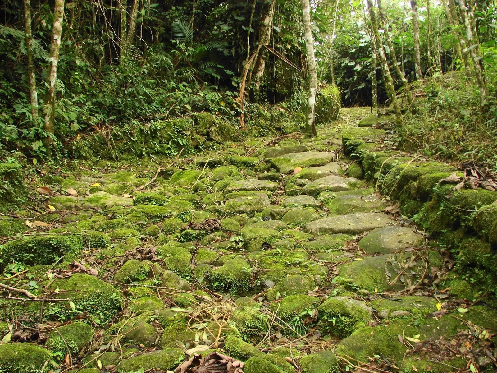
To make that possible, a road was built — paved in its steep sections with large, hand-set stones, climbing the escarpment in a way that has survived nearly three hundred years of rain. It was part of the larger network later called the Estrada Real, the "Royal Road," that linked the mining districts to the coast. Mule trains came down it loaded with gold and went back up it loaded with salt, tools, supplies and the enslaved Africans whose forced labour built and worked the whole system. None of that is decoration in the telling. The paving you walk on was laid by enslaved hands, and the better guides do not let you forget it.
Sections of the original road still exist in the forest above Paraty, and you can walk them. The preserved stretches are reached by guided visit — partly because they cross private land now, partly for protection — and honestly the guide is the point. The trail without the stories is just attractive paving; with them, it becomes one of the most affecting hours in the region. We've written the practical detail up separately in our Gold Trail guide, but the short version is: the trailhead is in the Penha district, a short drive from the centre; visits run in the morning; you walk a few kilometres of forest and stone; and you wear shoes that can handle wet, slick rock, because the stones get glassy when they're damp.
There is a neat geography to it, too. The Gold Trail and the area's best swimming holes share the same mountain road, so the natural shape of a day is: the trail in the cool of the morning, lunch, and then a waterfall to wash off the climb. That gives you the history and the forest and the cold-water reward in a single outing, without ever setting foot on a boat.
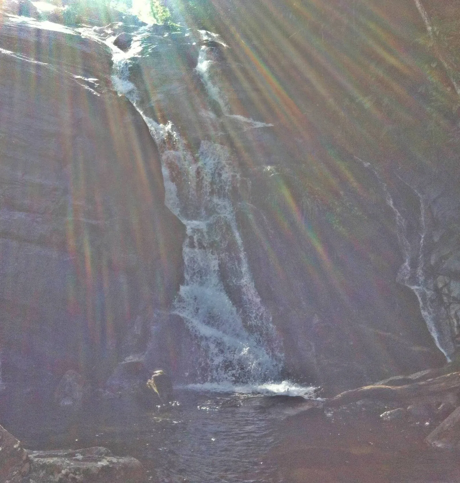
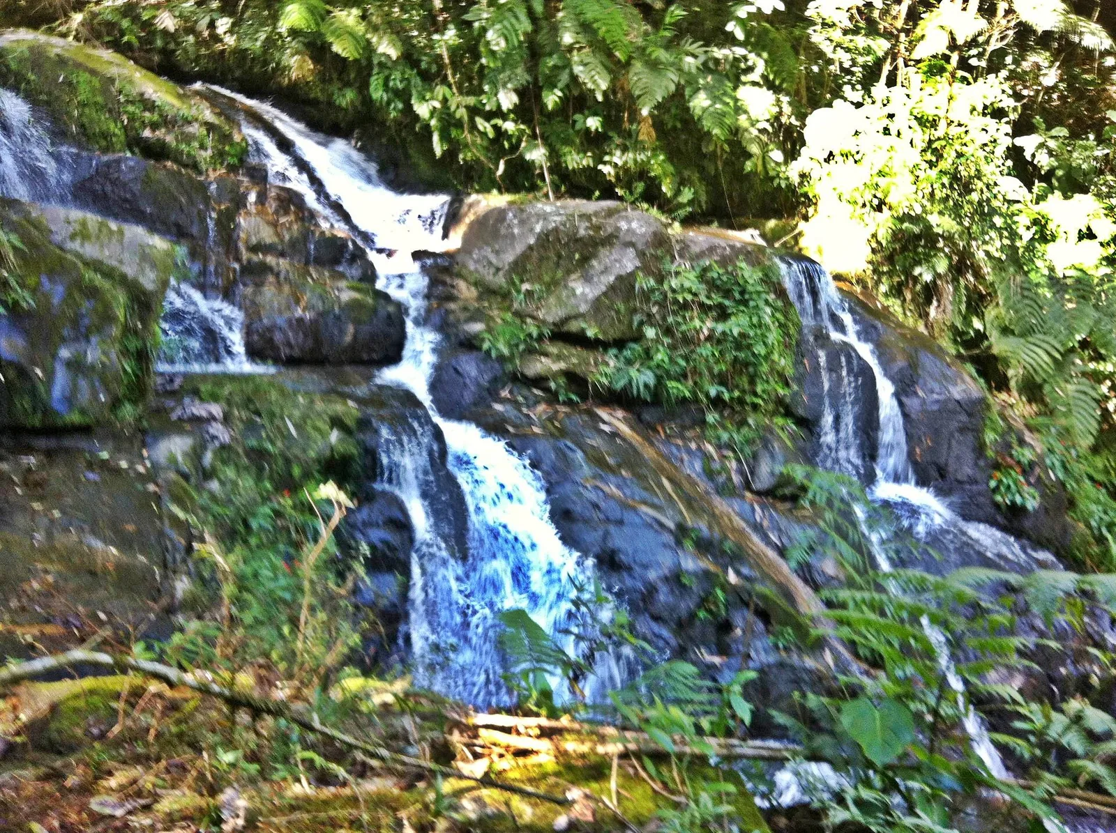
The waterfalls of the Paraty–Cunha road
If the Gold Trail is the mountains' history lesson, the waterfalls are their reward. The road that climbs from Paraty toward the highland town of Cunha — the RJ-165, becoming the SP-171 over the state line — runs straight up through the forest and is strung, the whole way, with cascades, natural rock slides and clear pools. Several of the best are on the Rio Taquari and its neighbours, and most are a short walk from where you leave the car.
The famous one is the natural slide — a long sheet of water-smoothed rock that the brave shoot down into a pool at the bottom, the kind of thing children and unembarrassed adults queue up for. Nearby are deeper pools for a proper cold swim and taller falls that are more for looking than for sliding. We keep a fuller list, with the temperaments of each, in the waterfalls guide, because they really do have temperaments — some are gentle, some have a current that deserves respect, and the character of all of them changes with the rain.
A few honest pointers, learned the way you learn these things — by getting them slightly wrong first:
- Go in the morning. The light is better in the gorges, the rock is less crowded, and you'll have the place closer to yourself before the day's tours arrive.
- Wear real shoes to the edge. The approach rocks are wet and slick, and flip-flops on glassy stone are how holidays get cut short. Change into nothing or into water shoes once you're in.
- Mind the water level. After heavy rain the gentle slide turns into something with real force, and a tame pool can develop a current. If it looks pushy, it is — sit it out and just enjoy the spray.
- The water is cold. This is mountain water off a forested escarpment, not the warm bay. It is gloriously refreshing and it is a genuine shock on the first plunge. That's the fun of it.
Bring a dry bag for phones, a towel, and a little cash — some pools sit on land where a local family charges a modest fee to park and use the path, which is fair, and keeps the place looked after.
Wildlife: what's really up there
People ask, reasonably, whether they'll see a jaguar. The honest answer is almost certainly not, and that is exactly as it should be. The Serra da Bocaina is one of the last strongholds in the region for big cats — jaguar and puma both range here, along with the smaller, more numerous ocelot — and the whole reason they survive is that they keep well away from people. What you are far more likely to encounter is the evidence of a working ecosystem: birdsong in layers, troops of monkeys moving through the high canopy, a tapir's tracks in the mud by a stream.
The species the conservationists are proudest of is the southern muriqui — the woolly spider monkey, the largest primate in the Americas, and one of the most endangered. A big male can weigh fifteen kilos with an arm-span over a metre and a half, and the park holds one of its surviving populations. Brown howler monkeys are here too, and their dawn and dusk chorus is one of the defining sounds of the Atlantic forest — a deep, rolling roar that carries for kilometres and sounds far larger than the animal making it. The first time you hear it from the chalet at first light, you'll understand why early peoples thought the forest was full of spirits.
The birds are the easier reward. Over three hundred species have been recorded in the park, and even a casual walker with no binoculars will pick out toucans crossing a clearing, tanagers flashing colour in the understory, and the absurd, jewel-bright saffron toucanet if luck is in. If you have any interest at all in birds, a guided dawn walk here is among the best you'll do in Brazil. There's more on the region's wildlife in our journal piece on the Atlantic forest's animals.
Going quietly is the whole skill
None of this rewards rushing. The forest hides everything that matters and reveals it only to patience. The travellers who come back glowing are not the ones who power-walked a trail to tick it off; they are the ones who stopped, stood still for ten minutes, and let the forest forget they were there. Hire a local guide who knows the calls — they will hear and name things you would walk straight past — and keep your voice down. The mountains give more to the quiet.
Guided access and the rules that keep it intact
The Serra da Bocaina is a protected area first and a destination second, and its access rules reflect that. They are not onerous, but they are real, and respecting them is part of the deal.
The preserved sections of the Gold Trail are visited by authorised guide only. The high interior of the park — the grasslands, the peaks, the long backcountry crossings — has its own controlled access, with permits and limited entry, and is genuinely the realm of organised expeditions rather than a spontaneous afternoon. And the famous cobbled mountain crossing that links Paraty to Cunha passes through the park's core, where, inside the protected zone, traffic is restricted to daylight hours and held to a crawl. These are conservation measures, and they are the reason the place is still worth protecting.
For most guests, the simplest route in is to book through one of the agencies in town, a day or two ahead, exactly as you would arrange a boat trip — we keep an overview on the tours page. A good operator handles the access, supplies a guide who actually knows the forest, and sorts the transport up the rough road so you arrive ready to walk rather than rattled. If you'd rather we point you to people we'd send our own family to, get in touch before you arrive and we'll set it up.
The cooler highland climate
One practical note that catches people out: the mountains run on a different climate from the coast, and the gap is bigger than you'd guess. Down at the bay it can be warm and humid year-round. A thousand metres up the Cunha road, it is reliably cooler, often misty, and after dark in the high country it can be properly cold. The cloud you watch gather on the ridges in the afternoon is real weather, and if you drive up into it you'll find a different world — damp, hushed, the temperature down ten degrees or more.
This is good news, not bad. The cool of the heights is the perfect antidote to a hot beach week, and the forest is at its most atmospheric when the mist is in it. But dress for it. Even in the Brazilian summer, take a fleece and something rainproof if you're heading uphill, because mountain weather turns without asking. In the cooler months — roughly May to September — the highlands can be genuinely chilly, and the clear, dry days that come with that season are also the best for the long views and the firmest footing on the trails. Our seasons guide goes into when to come in more detail, but for the mountains specifically: the drier, cooler half of the year is the easier time to be up high.
Reading the weather from the deck
You can learn to forecast the mountains' mood from the pool. When the ridges are sharp and bare against a blue sky in the early morning, the high country will be clear and the long views are on — a good day to go up. When cloud is already snagged on the tops at breakfast and creeping down, the gorges will be damp and the cobbles slick, and you might prefer a coastal trailhead or a later start. Afternoon build-up is normal in summer: the heat lifts moisture off the forest, it gathers on the heights, and by mid-afternoon the ridges vanish into grey. None of this is a reason to stay home; it's a reason to go early. The forest in mist is its own quiet reward, and the cascades run fuller after the rain. Just know what you're walking into and dress a layer warmer than the coast suggests.
Where the forest meets the sea
The Bocaina's strangest and most beautiful trick is the way it does not stop at the shoreline. The mountains fold straight down into the water, and in one place they enclose it. South of Paraty lies the Saco do Mamanguá — a long, narrow arm of the sea reaching back into the hills, hemmed by forested ridges on both sides, the closest thing Brazil has to a tropical fjord. The same range you walk on the Gold Trail is the range that rises sheer from the Mamanguá's banks, and from the water you get the clearest possible reading of the park's vertical drama: forest, all the way up, in an unbroken wall.
The signature climb here is the Pico do Pão de Açúcar do Mamanguá — a sugarloaf-shaped peak at the head of the inlet, reached on a steep, sweaty forest trail that delivers, at the top, one of the great views of the whole coast: the inlet curling below, the open sea beyond, the Bocaina's ridges marching off into the haze. It's a demanding walk in the heat and worth every step. We've given the Mamanguá its own full treatment in the Saco do Mamanguá guide, because it deserves it, but understand it as part of this story: it is the place where the national park's forest pours into the sea, and it shows you the mountains from the one angle the trails can't — from below, looking up.
A short history of the gold road
It's worth dwelling a moment on what actually happened on these slopes, because the mountains make far more sense once you know. For Brazil's first two colonial centuries, the interior was a near-blank to the Portuguese crown — vast, unmapped, and apparently empty of the riches the Spanish were prising out of their own Americas. Then, at the very end of the 1690s, bandeirantes pushing inland from São Paulo struck gold in the mountains of what became Minas Gerais — "the general mines." It was, for a while, the richest gold strike the world had seen.
The problem was getting it out. The mines were hundreds of kilometres inland, walled off from the sea by exactly the escarpment you're looking at. The first solution was Paraty: of all the points on the coast, this sheltered bay sat at the foot of one of the few passes a laden mule could climb. So the road was cut — the Caminho do Ouro — switchbacking up the Serra da Bocaina, paved in stone where the grade was steepest so the rains wouldn't wash it out. Down it came the gold, under guard, bound for the royal foundry and the tax-man's fifth, then onto ships for Rio and Lisbon. Up it went everything the mining districts couldn't make for themselves: salt, iron, cloth, tools, and people held in bondage.
Paraty boomed on it. The colonial centre's churches and merchant houses, the whole improbable elegance of the place, were paid for by the metal that passed through the port. And then, just as abruptly, it ended. The crown opened a shorter, better-defended road from the mines down to Rio de Janeiro, and the gold traffic abandoned Paraty almost overnight. The town slipped into a long, quiet decline — which is precisely why its 18th-century streets survive so perfectly today. It was too poor, for too long, to knock anything down. The forest, meanwhile, crept back over the old road, and held it, until the heritage age came round and decided the stones were worth saving. When you walk the Gold Trail now, you are walking the rise and fall of Paraty in a single morning.
Getting up there: the practicalities
The mountains feel remote and are, in fact, close. Here is the honest geography of reaching them.
The easy half
The lower trailheads — the Gold Trail entrance in the Penha district, the first of the waterfalls on the Cunha road — are a short, paved drive from the centre of Paraty, well under half an hour. Any car gets you there. This is the part of the park most guests actually experience, and it's enough: history, forest and a cold swim, all reachable in a morning. If you're booking a guided Gold Trail tour, the operator usually collects you and handles the short transfer to the trailhead, so you needn't drive at all.
The harder half
The full crossing toward Cunha is a different proposition. Above the lower waterfalls the road steepens, the asphalt gives way to cobbles, and the cobbles give way, in the worst stretches, to rutted track. Inside the protected core the speed limit is a crawl and the gate hours are daylight-only. People do drive it in ordinary cars in the dry, slowly and carefully, but it punishes a low chassis, and after rain it can be genuinely difficult. For the full mountain crossing, a high-clearance or four-wheel-drive vehicle is the sensible choice, and a guide or driver who knows the road is better still. If your aim is simply the waterfalls and the trail, you never need to attempt the rough section at all — drive the paved lower end, stop, swim, and turn back.
A simple rule
For the forest, the history and the falls, treat the mountains as a half-day from the door and don't overthink the vehicle. For the high country, the long crossing or the backcountry trails, treat them as a planned outing with the right transport and, ideally, a guide. Confuse the two — set off for Cunha over the cobbles in a hire hatchback after a storm, say — and you'll have a long, anxious afternoon. We're happy to help you tell them apart before you book; that's what the concierge note is for.
What to pack for a morning in the Bocaina
You don't need expedition kit for a standard mountain morning, but a little preparation turns a good outing into an easy one. For a Gold Trail walk and a waterfall stop, take:
- Real shoes with grip. Trail shoes or trainers you don't mind getting wet. The stone paving and the rock by the pools are slick, and this is the single thing people most often get wrong.
- A warm layer. A fleece or light jacket, even in summer. The temperature drops noticeably as you climb, and the mist carries a chill.
- Something rainproof. Mountain weather turns fast; a packable shell weighs nothing and saves the day.
- Swimwear and a quick-dry towel. You'll want both at the falls, and you'll be glad of dry clothes for the drive down.
- A dry bag. For phone, keys and camera. Pools and dry electronics don't mix.
- Water and a snack. There's little to buy once you leave town, and the air is thirstier up high than it feels.
- Insect repellent and sunscreen. The forest has both mosquitoes and, in the clearings, real sun.
- A little cash. Some pools and paths cross private land where a small fee keeps the place maintained.
Leave the rest. The mountains reward travelling light, and the chalet will be waiting with a warm shower and the whole bay below when you come down.
Where the chalet fits
What makes the Bocaina such a quiet luxury from here is simply where the chalet sits. At roughly four hundred metres above the bay, on the forested skirt of the range, you are already on the mountain — not in town, not at sea level, but up in the trees with the park rising behind you and the water laid out below. The howler monkeys you hear at first light are the park's. The mist that drifts across the pool on a grey morning is the same cloud you watch catch on the high ridges. The forest at the property's edge is the bottom edge of all of it. You can read more about that setting on the chalet page.
It changes how you use the mountains. You are not making a long expedition out of every visit; you are stepping out of one and into the other. A morning on the Gold Trail and a swim under a waterfall, then back up to the pool by lunch with the whole bay glittering below — that is a day you can have without effort from here, and it's the kind of day that ends up defining the trip. The sea is what people book Paraty for. The mountains are what they remember.
How to do the mountains well
If you do nothing else with the Serra da Bocaina, do this: give it one proper morning. Walk a stretch of the Gold Trail with a guide who'll tell you what you're standing on, then drive a little higher and swim in cold, clear water under the forest. That single outing gives you the history, the trees and the reward, and it asks almost nothing of you except an early start and the right shoes.
If the mountains take hold of you — and they do take hold of people — there is far more. Quiet dawn birdwatching. Longer forest trails for the genuinely fit. The full, rough crossing toward the ceramics town of Cunha over the cobbles, a day-trip in its own right for those with the vehicle and the appetite. The viewpoints where the whole coast unrolls beneath you. None of it is far. All of it is the other half of the Paraty you came for — the green, vertical, cloud-wrapped half that gives the famous sea its frame.
Turn around from the water now and then. The best view here might be the one behind you.
Frequently asked questions
Yes. The park sits directly behind Paraty and the coastal trailheads, waterfalls and the Gold Trail are reachable in well under an hour. The high interior and the cobbled Paraty–Cunha road are a longer, rougher drive and are best done with a guide or a capable vehicle.
The lowland coastal trails and most waterfalls are free to reach, though some sit on private land that charges a small access fee. The Gold Trail's preserved sections are visited by guided tour. The high mountain core has its own access rules and limited hours; check current conditions before you go.
The park spans from sea level to over 2,000 metres. Its highest point, Pico do Tira o Chapéu, reaches about 2,088 metres. That altitude range is why you can stand on a warm beach in the morning and need a fleece in the highland grasslands by afternoon.
The mountain road toward Cunha is lined with them — natural rock slides, swimming holes and tall cascades on the Rio Taquari and neighbouring streams. Most are a short, marked walk from the road. Go in the morning, wear shoes with grip, and check the water level after heavy rain.
The park shelters jaguars, pumas, ocelots, tapirs, brown howler monkeys and the endangered southern muriqui, the largest primate in the Americas. Birdlife is rich, with over 300 recorded species including toucans and the saffron toucanet. You're far more likely to hear the forest than see its rarer residents.
For the full crossing, effectively yes. The middle section through the park is steep, cobbled and rutted, with a low speed limit and daylight-only hours inside the protected zone. Many travellers drive only the lower, paved Paraty end to reach the waterfalls and turn back.
The Gold Trail (Caminho do Ouro) is the colonial stone road that climbs through the Serra da Bocaina. The mountains are the park; the trail is the historic route over them. You walk the trail to experience both at once — the forest and the 18th-century engineering that crossed it.